标题:基于全景影像生成城市道路区域GNSS卫星时空可见图
Mapping the spatio-temporal visibility of global navigation satellites in the urban road areas based on panoramic imagery
来源:International Journal of Digital Earth
作者:寇瑞雄,杨必胜,董震,梁福逊,杨树文
摘要
GNSS导航定位已经应用于城市生活的方方面面,如车辆和行人导航等。但在城市峡谷中,GNSS卫星遮挡十分严重,这种情况下,快速有效的确定城市道路区域不同时刻的GNSS卫星可见情况,对车辆和行人导航有重要意义。目前,城市道路区域卫星可见数能够通过GNSS接收机实地测量得到,但该方法时效性差、消耗大量人力,大范围测量不可行。一些方法使用三维城市模型,分析城市峡谷环境下GNSS的性能,预测GNSS卫星在城市峡谷环境下的可见性,但高精度城市模型的制作价格高和覆盖范围小。由于街景图像已经覆盖很多城市的道路区域,因此提出结合道路街景图像和GNSS卫星星历计算城市道路区域GNSS卫星可见情况的方法,具体流程如图1所示:
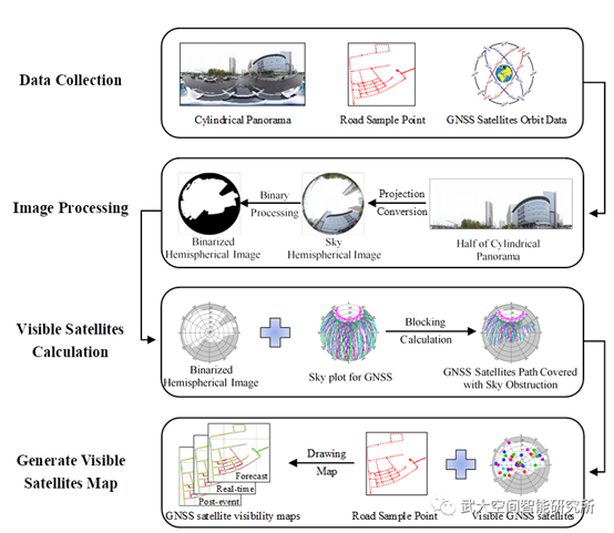
图1 方法流程图
为了验证该方法的可行性,以武汉市和上海市的部分道路为例进行实验。图2为上海市试验路段GNSS卫星可见仿真结果,其中图2(a)(b)分别为一遮挡严重区域A和一开阔区域B的详细卫星可见情况,图2(c)为实验区域整体实时GNSS卫星可见图。
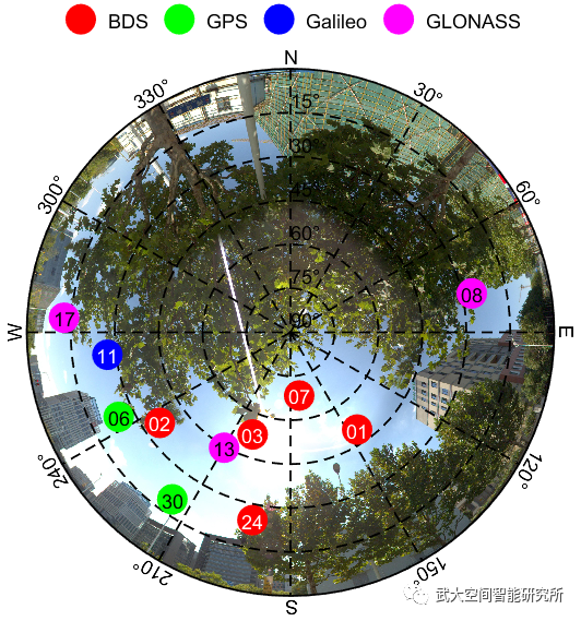
(a)
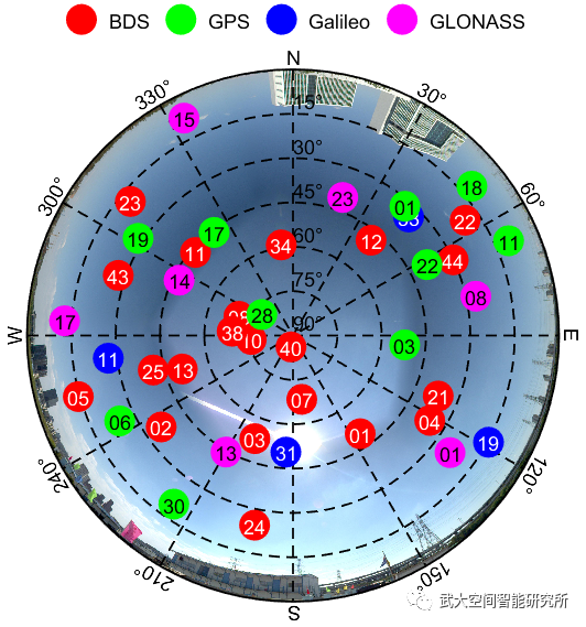
(b)

(c)
图2 上海市试验路段实时卫星可见图
实验结果表明,该方法为绘制城市GNSS卫星时空可见图提供了一种简单可靠的解决方案,为道路区域GNSS站点布局和定位质量评价提供了重要参考,丰富了高精地图的属性,为自动驾驶高精度实时定位和导航路径规划提供了科学依据。
Abstract
The satellite visibility number of GNSS is an important indicator for evaluating its availability for positioning and navigation. In urban areas, urban canyons cause serious satellite signals block, resulting in positioning uncertainty. Many studies used 3D city models to evaluate the visible satellites in some areas at a certain time. Nevertheless, this kind of method is difficult to apply because 3D models are not widely available. This paper thus proposes an easy method to evaluate the visibility of satellites with widely available street view panoramic imagery and GNSS ephemeris. The proposed method utilizes the locations of street view panoramic imagery and the associated GNSS ephemeris to calculate the visible satellite number at different times. Hence, the visible satellite number at a specific time can be mapped. Moreover, the visibility of satellites can be predicted according to its orbit parameters. To evaluate the effectiveness of the proposed method, Wuhan and Shanghai were taken to map post-event, real-time and forecast GNSS visibility. The experiments demonstrated that the proposed method provides a light weighted and easy to use solution to map the spatio-temporal visibility of satellites in urban areas, which is an important reference for GNSS stations layout and positioning qualities evaluation.
点击获取原文