概述
准确的高速公路线形和三维模型对数字交通新基建、数字孪生道路、高速公路改扩建工程等应用有重要意义。机载激光扫描能高效采集大范围、高精度的高速公路走廊三维点云数据,提供了优质数据支持。然而,利用机载点云进行自动化的高速公路线形提取和三维重建仍存在技术难点。
因此,本文提出了一个高效可行的技术框架,综合利用公路标线和边界的几何信息,通过最小化能量函数来提取高速公路线形,并用三维线形约束三维模型,提升三维模型精度。该方法在四川省的高速公路数据集上做了验证和测试,在
10cm
误差允许范围内的线形提取正确率超过
90%
,路面三维模型均方根误差为
2.4cm
,斜坡和山地为
5.8cm
。
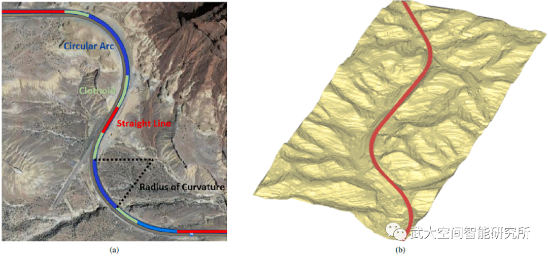
图1(a)高速公路线形;(b)高速公路三维模型
技术流程
1. 路面点云识别。
利用自适应的非地面点云滤波方法对植被、建筑物、机动车等非地面点云进行滤除。随后,利用平坦连通格网和路面边界逐点分析方法,从地面点云中识别路面点云。
2. 道路边界和标线提取。提取路面点云边界轮廓,并综合点云强度梯度和标线点方向信息提取高速公路车道标志线。
3. 线形提取和三维重建。首先自动识别圆曲线、直线和缓和曲线位置,然后最小化能量函数,该能量函数综合挖掘标线点云的位置信息和路面边界的方向信息,并约束不同曲线连接的平滑性,准确计算道路线形参数。最后,利用提取的道路边界线形作为约束,构建高速公路三维模型。
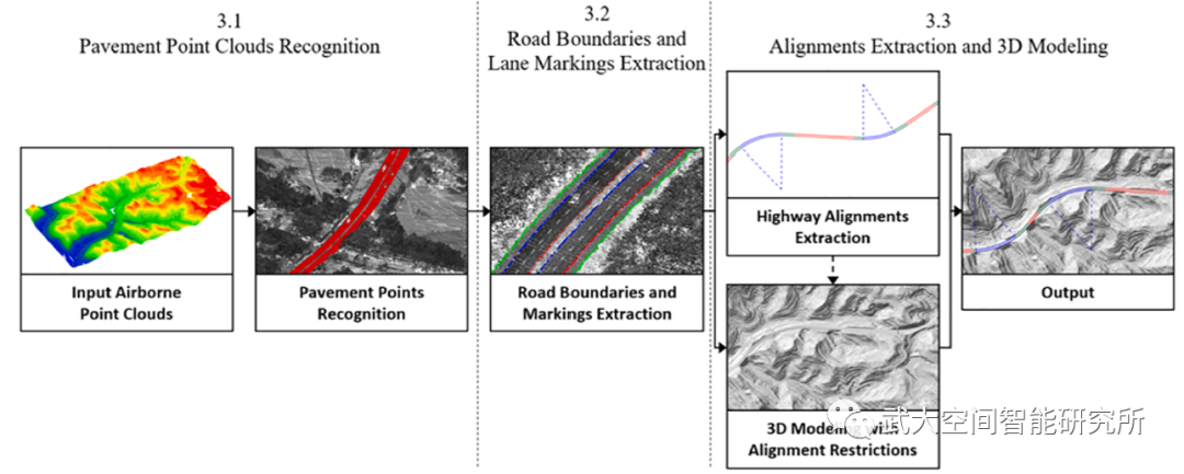
图2 文章技术流程
实验结果
在四川省高速公路数据集上验证了该方法,准确提取了高速公路线形参数,并构建了高精度道路三维模型,并进行了定量精度评价。
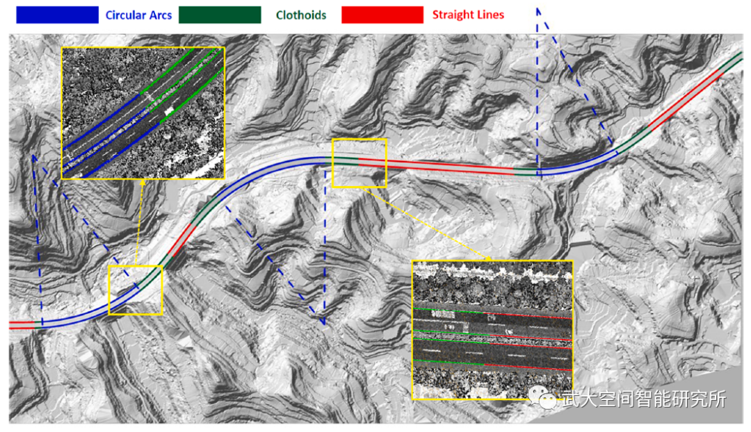

图3 高速公路线形提取和模型重建
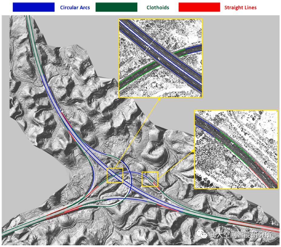
图4 高速公路(互通)线形提取和模型重建
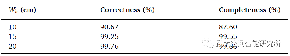
表1 不同误差允许范围(Wb)内的线形提取正确率和完整率
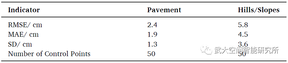
表2 高速公路三维模型精度指标
特别致谢
此工作完成期间,在数据采集和成果验证方面得到了四川省公路规划勘察设计研究院有限公司(原四川省交通运输厅公路规划勘察设计研究院)的大力支持,在此表示衷心感谢。
Abstract
Accurate highway alignments andthree-dimensional (3D) models are essential for various intelligenttransportation applications. Airborne laser scanning (ALS) provides a desirablemeans of data collection, which increases data quality and collectionefficiency. However, automatic alignments extraction and 3D modeling remainopen problems. Therefore, this paper proposes an automatic framework to extracthighway alignments by minimizing an elaborate energy function and reconstructhighway 3D models with the restrictions of alignments. Specifically, theproposed method contains the following steps: (1) Adopt an adaptive methodbased on spatially smooth and interconnected grid cells to recognize highway pavementpoints from ALS data. (2) Extract pavement boundaries and lane markings fromthe pavement areas using the α-shape algorithm and a marking tracking strategy.(3) Extract highway alignments by minimizing an energy function and reconstructhighway 3D models with the restrictions of alignments. The method was validatedin scenes of various highways, where the point density is 10-25 pts/m^2. Theextracted alignments respectively achieved the correctness of 90.67% and 99.25%and the completeness of 87.60% and 99.55% within 10 cm and 15 cm errors. Theroot mean square error (RMSE) of the generated 3D model is 2.4 cm on pavementand 5.8 cm on hills and slopes.