标题:融合全景影像和车载点云的交通标志信息提取
作者:虞敏,李雨昊,蒋腾平,王渊,董震,杨必胜
来源:测绘科学技术
摘要:
交通标志是城市道路交通设施的重要组成部分,对行人行车安全起着重要作用。本文融合激光点云和全景影像提出一种基于图像纹理、颜色、语义信息辅助的交通标志提取方法。本文方法在多个城市场景进行了定性与定量分析,实验结果表明本文方法能适应城市不同场景,点云标志平均提取正确率达97.9%,提取结果可以为城市交通标志规划验收、监测维护以及自动驾驶等领域提供科学辅助方案。
本文提出了一种基于图像的纹理、颜色、语义辅助的交通标志提取方法。首先,基于YOLOv3 网络目标检测对全景影像中的交通标志进行检测识别并输出相应的包围盒、类别信息;其次,经过预处理的点云通过标定参数文件和上述标牌检测结果建立对应关系,得到标牌在点云中的感兴趣区域(RegionofInterest, ROI),在ROI 范围内对标牌候选点进行聚类和筛选得到粗提取结果,投影到二维平面找到标牌的几何中心,再对标牌点云进行精确提取,具体流程图见图1。

图1 本文方法流程图

图2 测试场景原始点云和交通标志信息提取结果
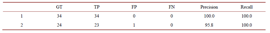
图3 测试场景中道路标志牌的实验结果
Abstract:
Traffic sign is a significant part of road traffic facilities in city scene and plays an important role in pedestrian and traffic safety. In this paper, by fusing laser point clouds and panoramic images, we propose a method to extract traffic signs in point clouds by using texture, color and semantics of images. The method in this paper has been analyzed qualitatively and quantitatively in several urban scenes. The experimental results show that the method in this paper can adapt to different urban scenes, and the average extraction accuracy of signs reaches 97.9%. The extraction results can provide a scientific auxiliary scheme for city traffic sign planning acceptance, monitoring and maintenance, as well as the fields of automatic driving.